the Creative Commons Attribution 4.0 License.
the Creative Commons Attribution 4.0 License.
 | 27 Feb 2026
Design and implementation of a robust data logging and satellite telemetry system for remote cryospheric research
Sunil N. Oulkar
Matthew W. Peacey
Michael Mitrev
Duncan J. Quincey
Bryn Hubbard
Tom Matthews
Ankita S. Oulkar
Katie E. Miles
Ann V. Rowan
Scientific research in remote environments has traditionally relied on manual data retrieval from data loggers, requiring multiple field visits that are costly, logistically challenging, and sometimes hazardous. While satellite telemetry solutions exist, their integration with widely used research-grade data loggers in extreme environments remains poorly documented, limiting reproducibility and adoption. This study presents the design and implementation of a data logging and telemetry system deployed in the Western Cwm of Mount Everest/Sagarmatha, Nepal, to transmit several meteorological parameters from an automatic weather station and firn layer temperatures obtained from a suite of borehole thermistors. Drawing on recent advances in satellite Internet of Things (IoT) connectivity, we present the integration and deployment of Campbell Scientific data loggers with Ground Control's compact satellite-enabled RockREMOTE Mini, which uses the Iridium Certus 100 networks and is powered by Iridium's 9770 modem. This work represents the first documented integration of research-grade Campbell Scientific loggers with Iridium Certus 100 satellite IoT technology, providing validated protocols, performance metrics, and automated workflows for extreme environments. The system, which operated at 6660 m a.s.l., in an extremely cold climate with a limited sky-view factor due to steep surrounding terrain, provided continual monitoring of ice temperatures and meteorological conditions transmitted every 24 h, from 4 May to 10 August 2025. Data integrity and transmission reliability were consistently maintained, with 100 % data retrieval, despite the challenging environmental conditions and limited power availability. The system established a robust methodological framework for other researchers working in remote locations, demonstrating the potential for sustained and high temporal resolution measurements of environmental conditions in locations where traditional communication infrastructure is unavailable.
- Article
(5444 KB) - Full-text XML
- BibTeX
- EndNote


The cryosphere is crucial for many Earth surface and climatic processes, regulating Earth's energy balance and global temperatures, and influencing weather patterns, ocean circulation, sea level and seasonal water storage (Fountain et al., 2012; Hieronymus and Kalén, 2020; Kulkarni et al., 2021). However, the cryosphere is changing at an accelerating rate (Hugonnet et al., 2021), with many glaciers predicted to disappear by the end of the century (Rückamp et al., 2025). Understanding the processes that govern mass and energy exchange across glacier surfaces and within subsurface firn environments is essential for predicting the future response of polar and high-mountain regions to climate change (Gardner et al., 2023; Hay and Fitzharris, 1988), but capturing these interactions reliably over time and across space remains a significant challenge. This is particularly the case in remote environments such as the Arctic, Antarctic, and high-mountain regions, where logistical access is severely limited and communication infrastructure varies greatly and is, in some cases, effectively non-existent, with only satellite communication available.
Current approaches to remote environmental monitoring rely primarily on periodic manual data collection and the deployment of equipment including Automatic Weather Stations (AWS). Various glaciological monitoring programmes have documented the difficulty of capturing in situ measurements of glacier dynamics, often requiring multiple field visits per season or year to maintain or modify equipment, retrieve data, and address sensor failure (e.g., Costanza et al., 2016; Martin et al., 2014; Martinez and Hart, 2010; Matthews et al., 2020a; Miles et al., 2018; Oulkar et al., 2024; Pernov et al., 2024; Tartari et al., 2009; Tetzlaff et al., 2017). Such expeditions incur substantial costs, involve safety risks, and present logistical complexities, which could be avoided with the availability of a data logging system equipped with satellite telemetry capabilities. Near-real-time telemetry directly supports investigation of glacier-climate interactions in high-mountain and polar environments by enabling continuous retrieval of mission-critical environmental data.
Existing satellite telemetry deployments in glaciology have primarily fallen into three categories (1) custom-integrated commercial systems combining sensors and telemetry in proprietary packages, which offer reliability but limit sensor flexibility and require notable capital investment; (2) purpose-built open-source platforms designed around specific satellite protocols (Garbo and Mueller, 2024), which provide transparency but require electronics expertise and may not meet the precision requirements of all applications; and (3) research-grade logger deployments with aftermarket satellite additions, which remain largely undocumented thus far. Our deployment addresses the third category by providing full documentation of a validated integration between Campbell Scientific CR1000/CR1000X loggers and the RockREMOTE Mini using Iridium Certus 100 connectivity. We implemented an integrated data logging and satellite telemetry system specifically designed for deployment in extreme high-altitude environments. The system combines Campbell Scientific CR1000/CR1000X data loggers with Ground Control's RockREMOTE Mini satellite communication units, based on Iridium Certus 100 connectivity to provide reliable data transmission from locations where terrestrial communication infrastructure is absent. We demonstrate the framework on which our system is built and provide access to our code so that others can replicate, adapt, and improve this design for their autonomous environmental monitoring purposes. The system demonstrates a novel approach by providing (1) complete integration protocols and open-source code, (2) quantified performance metrics from extreme conditions, (3) power management strategies and for sustainable long-term operation, and (4) automated data processing workflows that eliminate manual intervention. Existing deployments have typically used proprietary integrated systems or custom-built platforms (Nazir et al., 2017; Chan et al., 2021; Garbo and Mueller, 2024), limiting reproducibility for researchers using standard equipment. Here, we first present the design of the monitoring system, then describe its performance with an emphasis on the power and data management strategies used. We conclude with proposing telemetry protocols that are suitable for remote and extreme research settings.
The integrated data logging and telemetry system was deployed in the Western Cwm of Mount Everest/Sagarmatha, Nepal, at an elevation of 6660 m a.s.l. (27.97° N, 86.93° E), as part of a broader project to study near-surface energy exchanges and ice temperatures in the accumulation zone of one of the world's highest glaciers (Fig. 1). The Western Cwm contains the upper section of the Khumbu Glacier, which flows west from the Lhotse Face through the Khumbu Icefall, before turning south and terminating 5–10 km farther down-valley (RGI 7.0, 2023). The Western Cwm contains a series of mountaineering camps (Camp I, Camp II and Camp III) used for climbing Mt. Everest via the southeast ridge in Nepal and providing access to the high peaks of Lhotse and Nuptse (Fig. 1a and b). Despite having infrastructure in place to service the mountaineering community, deploying cryospheric monitoring equipment in the Western Cwm is both hazardous and expensive; in particular, fieldwork is challenging because of the extreme temperatures, the narrow weather window in which the site can be accessed, and navigating the icefall with its associated avalanche and rockfall risks, risk of heat and cold injury, and working at high elevation where low oxygen levels increase the likelihood of acute mountain sickness (Matthews et al., 2020b). Equipment deployment is further complicated by limited helicopter support, the need for climbing permits, physical limits on carrying loads, and the need for expert guiding. The development of an autonomous data logging and transmission system that reduced the need for regular field visits therefore had multiple benefits to the project team and reduced the environmental footprint of the research project.
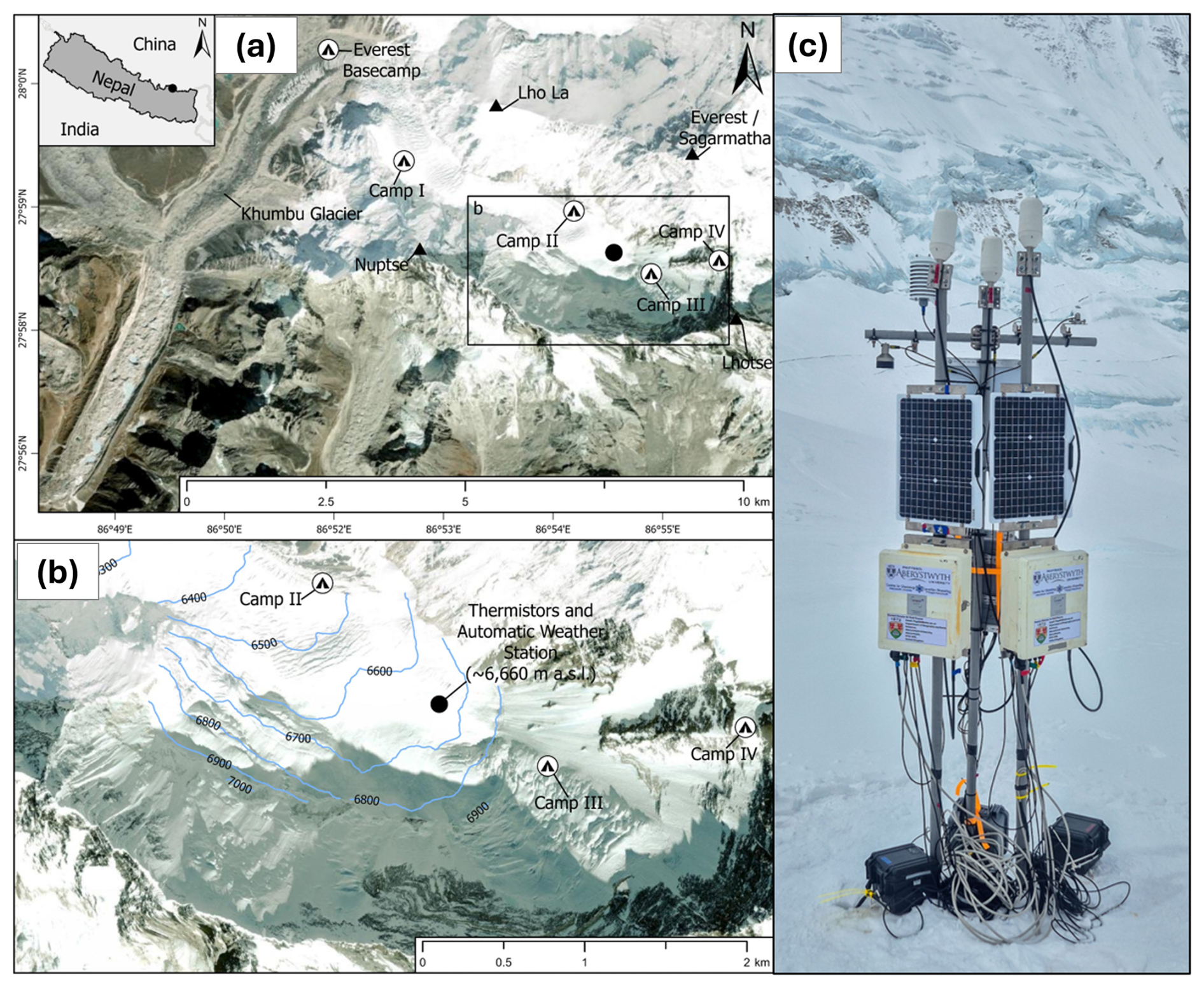
Figure 1(a) Khumbu Glacier and the surrounding area, shown by satellite image (ArcPro basemaps (Maxar)) (b) The field site, located in the Western Cwm of Mount Everest/Sagarmatha, Nepal, at an elevation of 6660 m a.s.l. (27.97° N, 86.93° E), and (c) fully deployed integrated monitoring system showing the complete telemetry enabled setup including AWS, thermistor borehole, solar power, CR1000/CR1000X enclosures, RockREMOTE Mini and satellite communication antenna for Iridium Certus 100 connectivity. Note that the cables were trimmed and secured to the mounting poles before final deployment.
The monitoring system included an AWS and two subsurface thermistor strings, connected to Campbell Scientific CR1000 and CR1000X data loggers respectively, each with an integrated RockREMOTE Mini satellite communication unit (Fig. 1c). Boreholes for the installation of thermistors were drilled into the firn layer to a total depth of 12 m using a Heucke Steam Drill (Heucke, 1999). The AWS incorporated meteorological sensors including air temperature, relative humidity, snow depth, incoming shortwave radiation and incoming and outgoing longwave radiation.
The system was powered by 12 V 24 Ah sealed lead acid batteries with 30 W lightweight solar panel charging arrays mounted vertically on the support mast. Data loggers and telemetry units for the AWS were housed in robust weatherproof cases and in Campbell Scientific enclosures for the thermistor arrays, mounted on glass-reinforced plastic poles installed 1.5 m into the surface. The RockREMOTE Mini satellite communication system was integrated with each data logger through a serial communication interface.
3.1 Data logger: Campbell scientific CR1000 and CR1000X series
The Campbell Scientific CR1000 and CR1000X (hereafter CR1000(X)) series data loggers are widely used for environmental monitoring in extreme conditions due to their reliability, extensive sensor compatibility, and flexible programming capabilities. While two different logger models were used, both share identical core functionality for our application and demonstrated equivalent performance throughout the deployment. They have been successfully deployed in the polar regions, high-altitude environments, and in a range of other challenging locations (Citterio et al., 2015; Doyle et al., 2018; Li et al., 2018; Sicart et al., 2014; Sugiyama et al., 2015), including at the Bishop Rock close to the summit of Mt. Everest/Sagarmatha (Matthews et al., 2022). The ability of the CR1000(X) loggers to operate across a wide temperature range (−40 to 70 °C) and their robust construction make them particularly suitable for deployment in harsh conditions, while their comprehensive analogue and digital input capabilities allow for integration with a wide variety of sensors commonly used in remote research. Additionally, the system's compatibility with multiple communication protocols, including satellite communication, offers the possibility of data transmission. The CR1000(X) loggers operate using the CRBasic programming language, which can accommodate complex data collection protocols, including conditional sampling based on environmental conditions, data quality control algorithms, and power management strategies. This functionality enables customised data collection and processing according to the specific research requirements of the user.
3.2 Telemetry system: RockREMOTE Mini
The RockREMOTE Mini, powered by Iridium's 9770 modem, is a compact, efficient, and robust version of the RockREMOTE family that operates on the Iridium Certus 100 network, developed by Ground Control Technologies United Kingdom Ltd (Ground Control, 2026a). Its physical components comprise a RockREMOTE Mini device, an antenna (Scan 65020-011), an Registered Jack-45 (RJ45) connector, Category 5 Enhanced (CAT-5E) ethernet cable, a combined power and serial communication General-Purpose Input/Output (GPIO) cable, 9 m of coaxial (LMR 400) antenna cable with N plug and TNC plug, and a bespoke antenna mounting kit (Fig. 2). The physical integration required three connections: (1) GPIO cable for power (12 V from logger) and serial communication, (2) LMR 400 cable to the externally mounted antenna, and (3) Ethernet cable for optional Power over Ethernet (PoE) (not used in our deployment). Its compact form ( mm) and robust IP66 rated enclosure are designed to make the device resilient to harsh weather conditions, including extended exposure to temperatures ranging from −40 to +70 °C and relative humidity ≤95 %. The RockREMOTE's low operating power consumption of <36 mW in sleep mode and ∼300 mW in idle mode supports efficient field operation. During Iridium transmissions, the unit draws an average of ∼7250 mW, with absolute peaks up to ∼20 000 mW during satellite uplink bursts. The availability of a sleep pin for dynamic power management makes the system ideally suited to solar-powered or battery-constrained deployments in remote environments.
The RockREMOTE Mini supports Iridium Certus 100 with Internet Protocol (IP) connectivity (up to 88 Kbps downlink, 22 Kbps uplink) and IMT (Iridium Message Transport), enabling both standards-based PoE integration via IP and scalable, efficient data transport via IMT. The IMT was selected over IP-based connectivity because its store-and-forward architecture is robust to the intermittent satellite visibility encountered at the field site. Complete messages are buffered within the transceiver and transmitted in small segments, resuming automatically if the link is interrupted. IMT remains operational at received signal levels of approximately −117 to −119 dBm, whereas typical IP-based connectivity operates over a stronger signal range of approximately −110 to −114 dBm and generally fails below −115 dBm, providing a 2–4 dB tolerance under weak-signal or obstructed conditions. These characteristics enable reliable one-way telemetry under low-power conditions. The limitations of IMT include a fixed message size limit (≤100 KB), meaning that applications requiring two-way communication, remote configuration, or larger data volumes may instead favour IP connectivity despite higher energy and cost requirements. The omnidirectional connectivity eliminates the need for precise antenna pointing, a significant advantage in dynamic environments such as the Western Cwm where equipment positioning moves due to glacier motion. Its versatile interface options, including Ethernet with PoE+, RS232/RS485 serial communication, and GPIO connectivity, enable integration with a wide range of sensor networks and data acquisition systems. The device's built-in Global Navigation Satellite System (GNSS) receiver provides a reliable time source for connecting equipment, while, Ground Control's cloud platform (Cloudloop), enables data integration and storage (see Sect. 7).
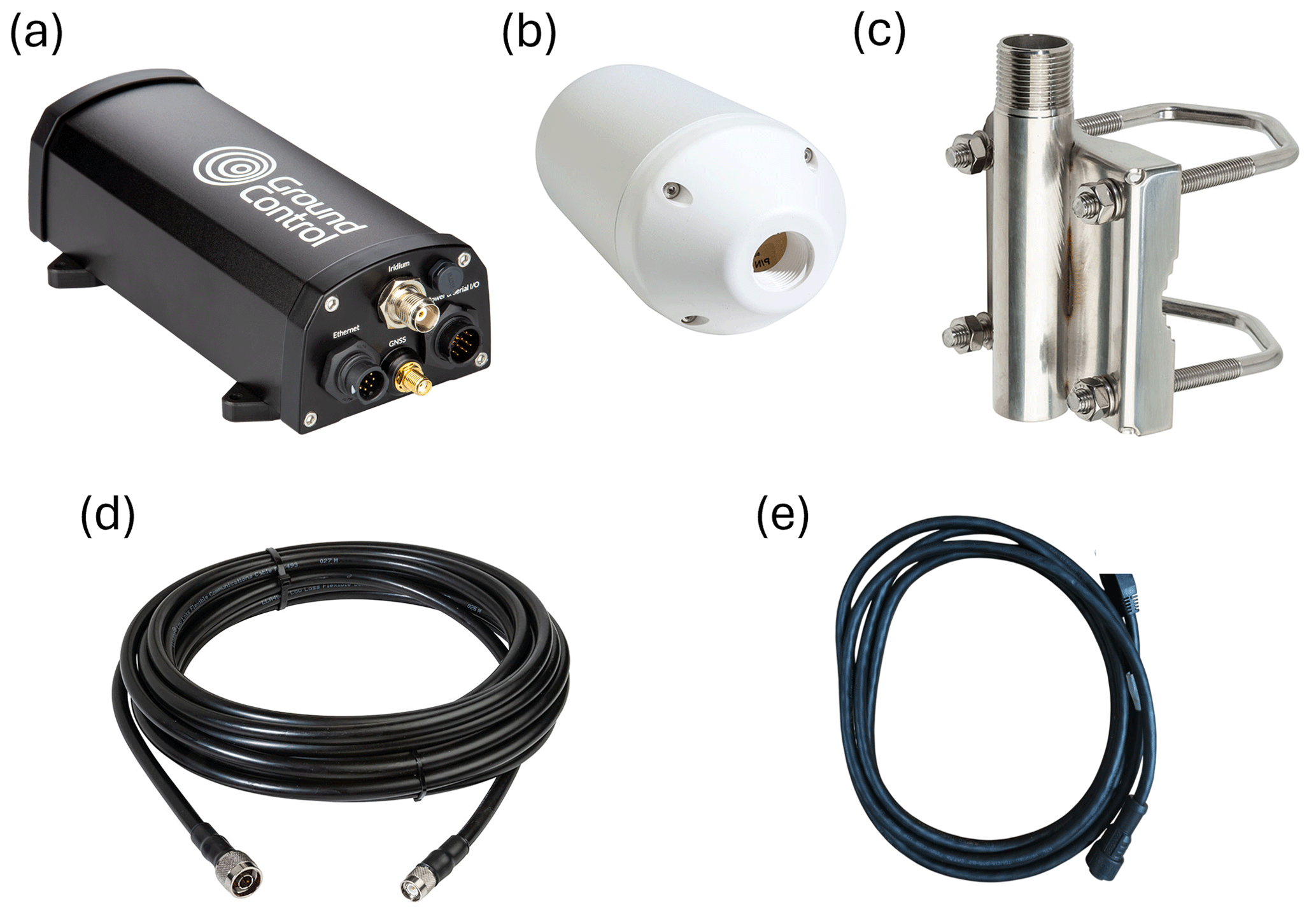
Figure 2Telemetry system components: (a) RockREMOTE Mini device, (b) RockREMOTE SCAN antenna (65020-011), (c) antenna mounting kit, (9d) m LMR-400 cable with N plug and TNC plug connectors and (e) GPIO cable. Source: https://www.groundcontrol.com/product/rockremote-mini/ (last access: 6 February 2026). Reproduced with permission.
3.3 Integration of data logger with RockREMOTE Mini
The CR1000(X) and RockREMOTE Mini have compatible communication interfaces and protocols (Fig. 3). The CR1000(X) native support for serial communication (RS232) aligns with the RockREMOTE Mini interface connectors, enabling their integration without requiring additional hardware adapters or protocol converters. The CR1000(X) CRBasic programming environment allows users to integrate AT command syntax by embedding the required ASCII prefix format (AT + CMD) followed by the payload and CRLF, facilitating direct communication with the RockREMOTE Mini and utilising the IMT protocol for efficient, low bandwidth data transmission. Power management is achieved through the CR1000(X) digital control outputs, which can directly interface with the RockREMOTE Mini sleep pin for intelligent power cycling based on environmental conditions or data collection schedules. The CR1000(X) built-in timing capabilities complement the RockREMOTE Mini GNSS receiver, ensuring precise data timestamping and synchronisation across multiple sensor networks. This compatibility extends to data formatting, where the CR1000(X) flexible data processing capabilities can optimise payload structures for IMT message-based transmission, maximising the efficiency of satellite airtime.
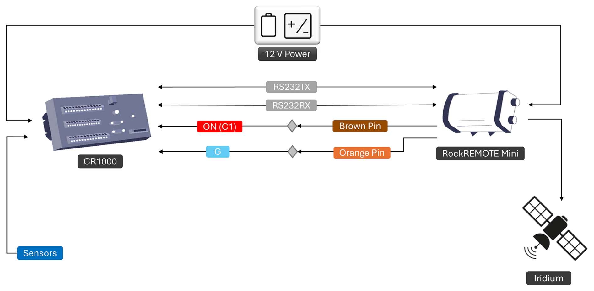
Figure 3Architecture of the remote monitoring system showing the integration of data logging, telemetry, power supply, and sensor components for autonomous operation in remote environments. Note: The middle four connection lines between the CR1000 and RockREMOTE Mini are GPIO cable. Adapted from https://www.groundcontrol.com/blog/integrating-rockremote-mini-with-cr1000/ (last access: 6 February 2026). Reproduced with permission.
3.4 Data logger programming
CRBasic provides the functionality to be able to handle multi-sensor data acquisition, implement intelligent power management, and design efficient satellite communication protocols optimised for remote monitoring (Fig. 4). The system implements the RockREMOTE Mini's IMT protocol support through serial communication at 115 200 baud, using the message-based approach that eliminates protocol overhead by transmitting data in Base64 format with no header information.
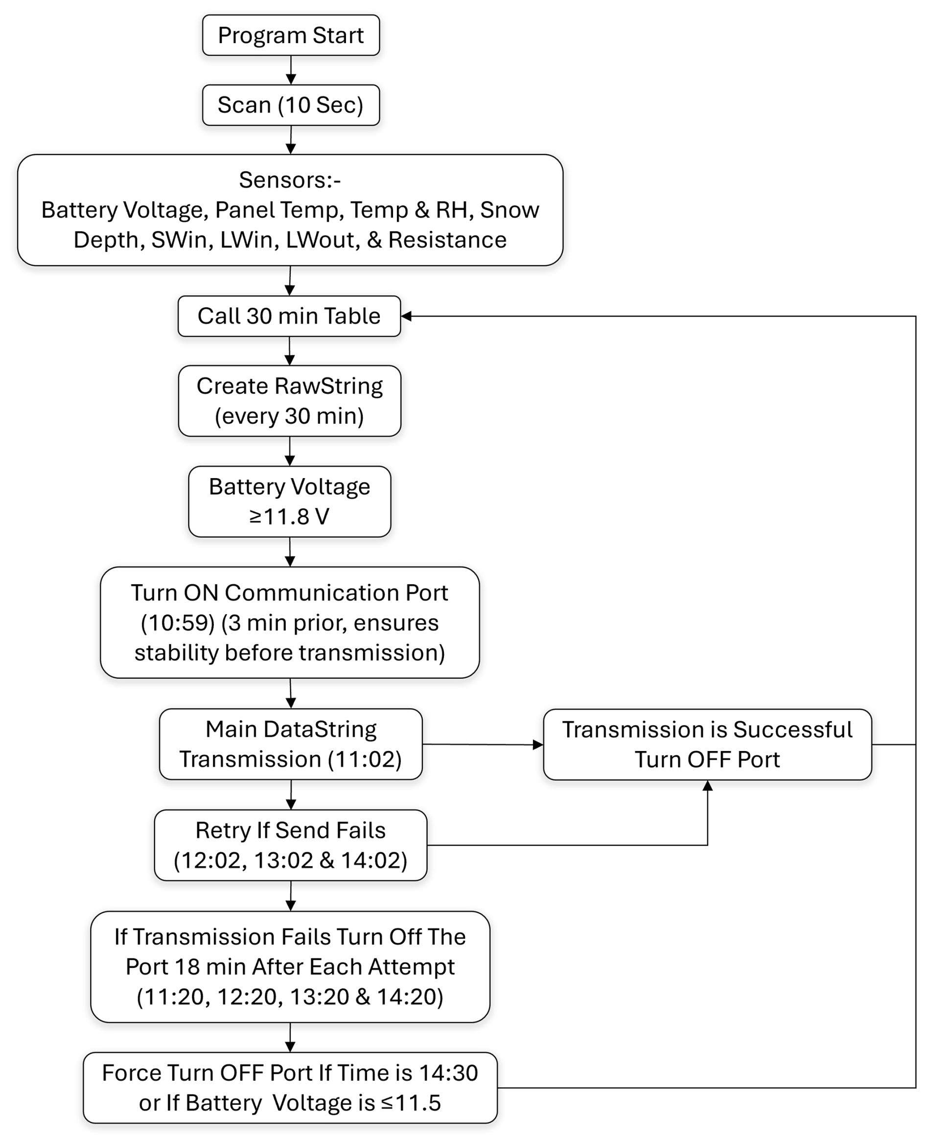
Figure 4Workflow of the CRBasic program for the CR1000(X), showing sensor initialisation, data acquisition, averaging, storage, and Iridium transmission with retry and power management logic. Panel Temp is panel temperature, Temp is air temperature, RH is relative humidity, SWin is incoming shortwave radiation, LWin is incoming longwave radiation, and LWout is outgoing longwave radiation and resistance is thermistor resistance.
Data acquisition and storage intervals can be programmed flexibly; for the Western Cwm deployment we scanned all raw data at the high-frequency interval of 10 s and saved average, minimum, and maximum values at lower frequency of 1800 s (30 min). While all data were written to the data logger memory for long-term storage, only the low frequency 1800 s values were transmitted via the telemetry system. This dual resolution approach ensured the measurement and recording of rapid environmental variability while maintaining manageable data volumes for satellite transmission. The CRBasic code to achieve this is available at https://doi.org/10.5281/zenodo.16985625 (Oulkar et al., 2025).
The RockREMOTE Mini sleep pin provides dynamic power control, with the program automatically activating the satellite modem 3 min before scheduled transmissions to ensure communication stability while minimising power consumption during dormant periods. With sleep mode enabled, baseline power consumption is reduced to <36 mW at 12 V (∼75 mW at 24 V), with the Iridium 9770 transceiver drawing power primarily during scheduled transmission periods. Without sleep-pin management, continuous modem operation would dominate total power use, requiring larger batteries or substantially larger solar arrays (∼50–75 W compared with the 30 W array deployed). This interval is user-configurable and can be adjusted based on specific deployment requirements or environmental conditions. The transmission protocol implements a 24-hour data collection cycle with primary transmission scheduled at 11:02 LT, followed by systematic retry attempts every hour (i.e., at 12:02, 13:02, and 14:02 LT) if initial transmission fails (Fig. 4). This schedule aligns with peak solar radiation periods to ensure the batteries are optimally charged during transmission attempts. In cases where daily data transmission fails completely, the system implements a cumulative data buffering approach where non-transmitted data are appended to the following day's dataset. The accumulated data follow the same scheduled transmission protocol the next day at 11:02 LT, with systematic retry attempts if required. The system can continue accumulating and transmitting multi-day datasets for 4 d, with the transmission capacity ultimately limited by the size limits of the satellite communication protocol (100 KB) or the character limit, which was set to a string limit of 25 000 characters based on the available memory size in the logger. As new data are appended at the start of the string, characters beyond the limit are truncated, ensuring that the most recent data are always retained. The program also incorporates subroutines that manage message tracking, status verification, and automatic retry mechanisms, with each transmission attempt generating a unique message identifier that denotes its success or failure status. For this deployment, the RockREMOTE Mini was programmed to operate on a scheduled duty cycle to minimise power consumption. The modem remained in sleep mode for the vast majority of time, drawing only 36 mW per 24 h period. Active operation was programmed to occur within an approximately 11 min daily window, comprising around 3 min for wake-up and satellite acquisition and up to 8 min for data transmission, depending on message size and satellite link quality. This duty cycle reduced modem power consumption by 97 % relative to operation in a continuously idle mode.
The string parsing and data formatting protocols of RockREMOTE Mini implement the AT command syntax required for IMT (messaging size up to 100 KB per message) communication (Ground Control, 2026b), with the program dynamically constructing transmission strings that include timestamp information, sensor data with appropriate precision formatting, and delimiting characters that enable efficient server-side data parsing. AT + IMTWU (MO IMT in Binary Mode without CRC, 100 KB per message) commands initiate binary data transmission with dynamic length specification based on the formatted data string. Message status tracking utilises the IMT protocol's built-in acknowledgement system, with the program monitoring response codes to determine transmission success and implementing automatic message cancellation and retry protocols when transmission failures are detected. AT + IMTMOS (IMT MO Status) commands are used to query transmission state through response code parsing, with successful transmissions indicated by state code “5”, while failed attempts trigger AT + IMTC3 message cancellation commands followed by automatic retry sequences, as described above.
Power management represents a critical design challenge in high-altitude deployments where solar charging is limited by weather conditions and seasonal variation in illumination. The sleep pin-based power management strategy proved highly effective during the deployment. By placing the modem into sleep mode between scheduled transmissions, daily power consumption was substantially reduced compared to continuous operation, making this approach essential for long-term autonomous deployment in energy constrained environments. Wake up procedures were reliable, with no observed failures, and satellite acquisition times were consistent with effective operation under restricted sky-view conditions. Our system implements an energy management strategy that seeks to balance system performance with power conservation requirements. The CRBasic program transmits only when battery voltage is ≥11.8 V, and the transmission process shuts down completely at voltages that are ≤11.5 V to prevent deep discharge damage to the battery. Figure 5 shows battery voltages for all three of our deployed loggers during the period of operation, ranging with strong diurnal cyclicity (reflecting solar charging) between 12.5 and 14.5 V.
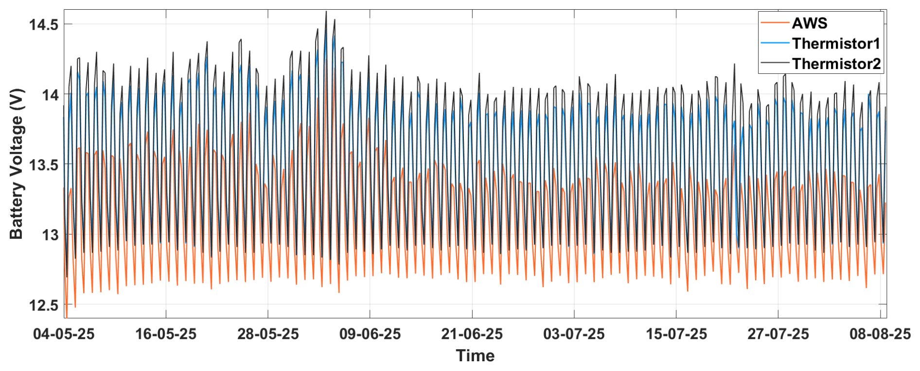
Figure 5The 30 min minimum recorded battery voltage during the monitoring period for the three lead-acid batteries powering the deployed loggers (one for the AWS and two for the thermistor strings), indicating power system performance under remote deployment conditions.
The Cloudloop Internet of Things (IoT) platform serves as the interface through which data transmitted by the RockREMOTE Mini can be accessed (Fig. 6a). It provides robust long-term data storage and integrity, and is built on AWS and uses Message Queuing Telemetry Transport (MQTT), with modern data integrity mechanisms and up-to-date security certificates. By default, data are retained indefinitely unless a customer modifies retention settings. Iridium messages are received at the Tempe, Arizona Ground Station and routed via Ground Control's SQS queue (IMT) or MPLS (IP) to Ground Control's NYC POP, which features redundant servers and routers across both sites with dual independent MPLS circuits. Cloudloop maintains 100 % uptime (https://status.groundcontrol.com/, last access: 6 February 2026), and background message forwarding continues even if the web portal is unavailable. These features ensure reliable, redundant storage and continuous data delivery, minimising the risk of data loss or service interruption. It provides seamless handling of Iridium IMT messages, device management, and downstream data forwarding. While alternative workflows are possible, they require direct integration with Iridium's backend via Amazon Simple Queue Service (SQS) and custom parsing to separate messages by device, whereas Cloudloop performs these operations automatically. Cloudloop also provides over-the-air configuration and firmware updating, usage reporting, and API access without additional usage-based fees, reducing operational burden and enabling remote management throughout the deployment. The data received from the RockREMOTE Mini arrive in Base64 format, but each message can be visualised as HEX and ASCII within the Cloudloop interface (Fig. 6b). The platform distinguishes between different message types (e.g. start-up routines, successful data receipt, failed transmissions, routine logs) and provides detailed payload information for each successful transmission, as well as logging precise timestamps, message sizes, and transmission success rates, so that data integrity and system performance can be tracked. Cloudloop's onward delivery methods are Email, Azure, AWS, Google Storage, FTP, HTTP Webhook and MQTT, +ThingSpeak and ThingsBoard.
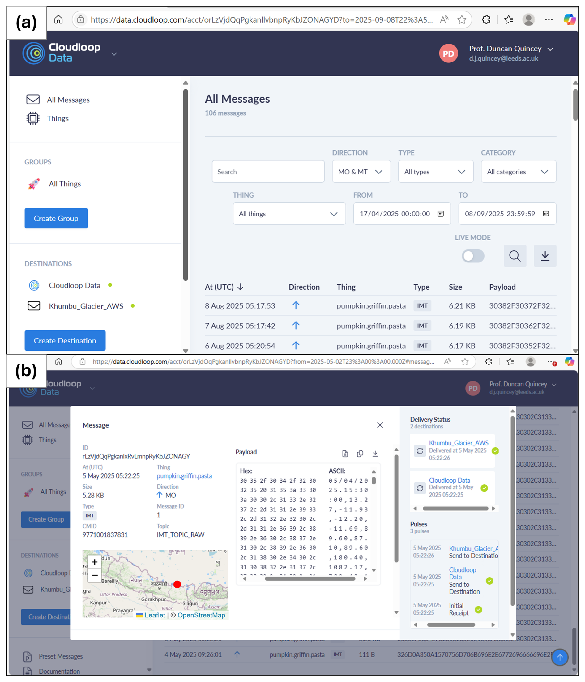
Figure 6Cloudloop IoT dashboard showing (a) telemetry data from the RockREMOTE Mini with timestamps, type, message size, and payload (b) Detailed message in the HEX and ASCII format (Basemap from Leaflet, ©OpenStreetMap).
In our implementation, Email serves as the primary channel for data transfer for extraction. The system is configured to dispatch an email on receipt of every new message, which has proved to be a simple but reliable mechanism for near real-time data forwarding without requiring API integrations. This provides an effective means for conducting daily quality checks and facilitating the integration of our data into downstream processing pipelines.
To automate the extraction, transformation, and loading (ETL) of telemetry data received via Cloudloop's Email delivery method, we implemented a Microsoft Power Automate-based workflow that eliminates manual intervention in the satellite-to-analysis pipeline (Fig. 7). Alternative approaches include custom scripts in Python or R, cloud-based services such as AWS Lambda, or other automation platforms like Zapier, depending on user preference and expertise. Once Cloudloop receives data from the RockREMOTE Mini and sends an automated email containing the HEX payload, the Power Automate flow is triggered (Fig. 8). The flow monitors the inbox for incoming messages from Cloudloop and retrieves the required HEX payload from the email body. The system then reads the existing HEX data file to retrieve previously stored observations, appends the new payload, and saves the combined dataset as a text file in a designated location, preserving continuity across transmission cycles. The Power Automate workflow implements multiple error-handling mechanisms. (1) Missing emails: The workflow is event-driven and triggers only upon email arrival, it does not poll for expected transmissions. If a scheduled transmission does not arrive, the system continues operating normally, with the gap becoming apparent during routine quality control. (2) Malformed emails: The workflow checks for the presence of HEX payload markers. Emails lacking valid markers are skipped and treated as data gaps rather than causing system failure. (3) HEX decoding failures: In Excel, the decoding formulas verify that payloads contain valid hexadecimal pairs (0–9, A–F). Payloads failing this check are discarded, preventing propagation of corrupted values into the data pipeline. In all error scenarios, original Cloudloop messages remain accessible through the web interface, providing a recovery pathway for manual retrieval if required. Following this ETL sequence, we implemented Power Automate within MS Excel to automate reading the updated text file, converting the HEX encoded content into ASCII format, and loading the decoded data into a structured dataset for analysis. Excel has significant structural and performance limits, most notably a maximum of 1 048 576 rows and 16 384 columns per worksheet, with individual cells capable of holding up to 32 767 characters. Practical limits also apply to total file size, which becomes memory- and system-dependent as files grow.
The whole process is completed within tens of seconds, meaning the data are accessible in analysis-ready format within ∼1 min from the workflow being initiated at the monitoring site. Small delays can arise during data transformation and refresh time within the Excel workbook, which can be tackled by directly using the HEX file with Python or similar programming languages. The Power Automate flow and associated files are available at https://doi.org/10.5281/zenodo.16985625 (Oulkar et al., 2025).
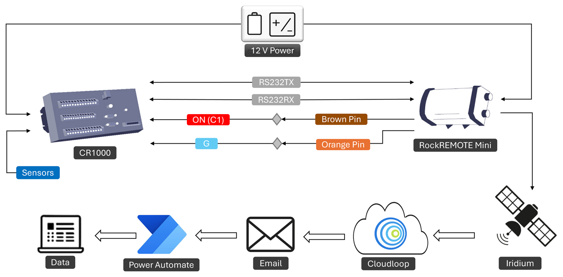
Figure 7Remote monitoring system architecture schematic illustrating the complete data pathway, starting from RockREMOTE Mini, then transmitting via Iridium satellite, followed by processing on the Cloudloop platform, subsequent email delivery, integration with Microsoft Power Automate ETL workflow, and concluding with the final processed dataset. Adapted from https://www.groundcontrol.com/blog/integrating-rockremote-mini-with-cr1000/ (last access: 6 February 2026). Reproduced with permission.
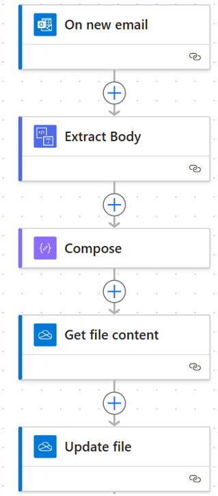
Figure 8Power Automate workflow for automated extraction, transformation, and loading of HEX telemetry data into an Excel-ready format.
7.1 System performance and reliability
Our deployment used separate data loggers and telemetry units for the AWS and each of two thermistor strings. This configuration reflected both the scientific objectives and the practical field constraints of the Western Cwm installation. Using independent systems facilitated rapid verification and troubleshooting during the short installation window and reduced the risk of a single point of failure interrupting all data streams. While architectures based on a single logger and transmitter may offer advantages in deployments easier access the modular approach adopted here was the most robust for this campaign. The integrated data logging and telemetry system, combining the CR1000(X) data logger with the RockREMOTE Mini Iridium (Encompassing the Iridium 9770 transceiver), proved to be robust and reliable throughout its operation, successfully transmitting data from its deployment on 4 May 2025, until 10 August 2025. Measurements ceased on 10 August because the above-ground elements of the installation were either buried by snow or displaced by an avalanche (confirmed by field visit on 21 September 2025), rather than by any malfunction of the telemetry system itself. The system's resilience during extensive cloud cover, typical of the monsoon season, has been particularly noteworthy, with successful data transmission maintained even during periods of heavy overcast conditions that typically challenge satellite communication systems. Indeed, transmission data show that across all three setups (AWS and two thermistor strings), 273 out of 293 total transmission attempts were successful on the first attempt, representing a 92 % first-attempt success rate. Of the remaining 20 transmissions, 17 were transmitted on the second attempt, and the remaining three were transmitted on the subsequent day (Fig. 9). Notably, the next-day transmission protocol was successful on all three of these occasions resulting in 100 % data recovery throughout the deployment period. Figure 5 confirms that battery voltages remained consistently above transmission thresholds (>12.5 V) throughout deployment, including all days when first-attempt failures occurred. This shows transmission failures resulted from satellite link issues rather than insufficient power. Iridium's satellite constellation provides global coverage, but periodically, only a few satellites may be visible from a ground location. At our site, steep surrounding terrain (Lhotse Face, Everest West Ridge, Nuptse) reduced visible sky, decreasing satellite pass opportunities. The 1-hour interval between retry attempts ensured new satellite passes became available, explaining the 100 % success rate within two days.
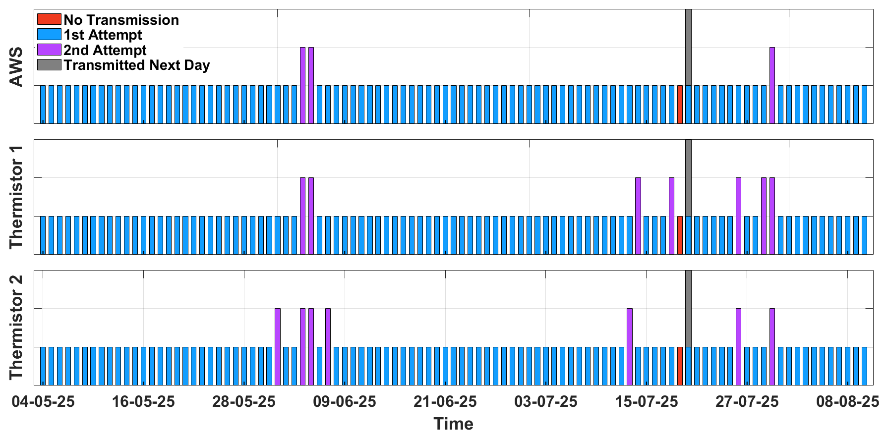
Figure 9Data transmission performance of the AWS and both thermistor datasets, showing daily data delivery attempts. Blue bars indicate successful first attempts, purple bars indicate second attempts, red bars indicate no transmission and grey bars shows successful transmissions on the following day first attempts.
Similarly, the battery system performed reliably throughout the operating period (Fig. 5), with no sign of voltage drop or power failure. However, we note that during the winter season or cold conditions, lower temperatures would present a more significant challenge to maintaining the battery charge.
System performance in other regions will depend on satellite availability and terrain conditions. Satellite availability differs substantially between our mid-latitude site (27.97° N) and polar regions. High Arctic/Antarctic (>70° latitude) advantages include more satellite passes (orbits converge at poles, increasing visible satellites), longer visibility duration, and higher success probability. We anticipate further improved first-attempt success rates relative to the 92 % observed at our site, due to improved satellite geometry. However, polar researchers should note that while satellite visibility improves, the local terrain still matters. Sites in valley bottoms or near ice cliffs may experience similar occlusion effects. Overall, it is reasonable to expect that the system would perform equal-to-better in polar regions from a communication perspective, with power management becoming the primary design challenge during winter darkness.
The CR1000(X) platform was selected for four primary reasons (1) proven reliability in extreme environments, with documented operation from −40 to +70 °C; (2) compatibility with a wide range of research-grade meteorological and thermistor sensors required for cryospheric studies; (3) programming flexibility through the CRBasic environment, enabling custom power management, conditional sampling, retry logic, and direct AT-command control of satellite modems; and (4) extensive community adoption and institutional support, reducing development and operational risk. Compared with low-cost platforms such as Raspberry Pi or Arduino (Nazir et al., 2017; Chan et al., 2021), the CR1000(X) provides a favourable balance between power efficiency and advanced functionality, including native RS-232 interfaces, precise timing, programmable digital I/O, and support for differential analogue measurements without external signal conditioning. However, alternative data acquisition systems may be appropriate under different application-specific constraints. Other platforms, including low-cost platforms like Raspberry Pi (Nazir et al., 2017), Arduino (Chan et al., 2021), Cryologger Ice Tracking Beacon (ITB) (Garbo and Mueller, 2024), HOBO RX3000, Vaisala AWS310 and DL-Series or commercial microcontrollers, may also be sufficient for simpler deployments or where rapid prototyping is needed. Indeed, these systems may be preferable under different conditions, including application-specific constraints such as environmental severity, required precision, sampling frequency, maintenance feasibility, cost, robustness, ability to operate across large temperature ranges, power demand, and acceptable deployment duration.
The RockREMOTE Mini was chosen based on (1) ultra-low power consumption (300 mW operating, enabling solar-battery systems); (2) Iridium Certus 100 compatibility, providing truly global coverage including polar regions; (3) an omnidirectional antenna, eliminating pointing requirements in dynamic remote environments; (4) serial interface compatibility with CR1000(X), enabling direct integration without protocol conversion; and (5) message-based IMT protocol support, allowing efficient low-bandwidth transmission (up to 100 KB per message) optimised for environmental monitoring. Satellite modem alternatives such as MetOcean's STREAM series also provide comparable telemetry capabilities and may be selected depending on application-specific criteria such as power constraints, data volume, latency tolerance, operational costs, support availability and integration needs. Further, the current deployment relied on the RockREMOTE Mini modem operating over the Iridium satellite network due to its global coverage and low power demand, but also for its favourable balance between power consumption, supported message payload size, operational robustness, and tolerance to restricted sky visibility. In addition to global coverage, the RockREMOTE Mini with Iridium Certus 100 supports store-and-forward operation, short transmission windows, and single-message payloads of up to 100 KB, enabling fully automated daily data delivery with minimal latency under constrained power budgets and intermittent satellite visibility conditions that are difficult to achieve simultaneously in geostationary or broadband systems. Several alternative satellite communication options are also available and may be more suitable for different use cases. Platforms such as Thuraya and Inmarsat offer regional geostationary coverage with higher bandwidth but typically may require more power and line-of-sight stability, making them more effective at lower-latitude and less obstructed environments. Other satellite communication platforms include ARGOS, which offers global coverage but with limited positional precision, and Globalstar, which provides cost-effective communication but lacks reliable coverage at high latitudes (Garbo and Mueller, 2024). Starlink offer high-bandwidth data transfer and expanding global coverage through a growing constellation of low-Earth-orbit satellites. However, such platforms may currently require significantly higher power and infrastructure. Additionally, access may be restricted in certain regions due to geopolitical or regulatory limitations. As a result, the use of these platforms in autonomous remote monitoring remains constrained both technically and operationally. Relative to other telemetry systems, the Iridium Certus 100 link supports modest data volumes with short transmission durations and high delivery reliability, enabling consistent daily messaging without continuous sky visibility. The compact omnidirectional antenna eliminates pointing requirements and reduces mechanical failure modes, while the wide operational temperature range enables deployment in cold environments without additional environmental conditioning. Together with aggressive duty-cycle power management and a modular system architecture, these characteristics represent a substantial improvement over many previously reported telemetry deployments, for which power consumption, latency, or transmission reliability are often described only qualitatively. As a result, low-power Iridium-based systems provide a robust and operationally efficient solution for remote cryospheric and high-mountain deployments where power availability, sky visibility, and site accessibility are the dominant constraints.
The upfront cost of the telemetry system reported herein, including hardware and Iridium communication, ranges from GBP 1700–2000 per site, and data plans cost some tens of GBP per month (with ours being GBP 20–30), these expenses are outweighed by efficiency savings on travel to remote environments. In contrast, manual data retrieval campaigns in remote regions generally exceed GBP 5000 per person for alpine or Arctic expeditions, and substantially greater for Antarctic and high-mountain expeditions. These expeditions often require extensive logistics, helicopter access, permits, specialist equipment, and in-country personnel, incurring further costs. Additional complications can arise from extreme weather, technical terrain, exposure to illness, and physical and mental strain, in some cases leading to aborted trips where the data cannot be retrieved.
The nature of the environments that the sensors are deployed in can also lead to data loss from destruction of equipment. This can occur from avalanches, equipment melt-out, loggers falling into crevasses and destruction from local wildlife (Immerzeel et al., 2014). In some deployments, sites may not be safely visited at all after installation (e.g., on fast-moving ice, in an icefall, on an iceberg), making satellite telemetry the only practicable method of data retrieval. Such telemetry-based systems not only eliminate the need for repeat access but also reduce the risk of complete data loss in the event of equipment failure or loss. Additionally, the ability to monitor equipment status in real-time enables early fault detection, potentially allowing a rapid response to resolve the issue, and maximises data recovery thus improving the scientific return. Indeed, although our installation is no longer functioning, the data are stored in the cloud, within the automated email receipts, and locally as part of the Power Automate workflow, rather than solely on the loggers that may or may not be retrievable during the next fieldwork season.
Real-time data access through satellite telemetry substantially reduces scientific risks in remote deployments. Without telemetry, equipment failures may remain undetected until the next field visit-often months later-by which time instruments may be buried, displaced, or destroyed. This results not only in ongoing data gaps but also in the loss of data already stored on the logger. Telemetry enables early detection of sensor burial (through declining signal amplitude), melt events (firn temperatures approaching 0 °C), equipment exposure (abrupt thermal changes), or system malfunctions (battery voltage drops, transmission failures). Early recognition provides lead time for field teams to plan maintenance access while systems remain recoverable. In our deployment, the structural collapse on 10 August 2025 would likely have resulted in complete data loss had telemetry not been integrated, instead, all data through the failure point were successfully recovered via cloud storage and automated workflows.
While our deployment demonstrates the clear benefits of satellite telemetry for continuous monitoring in remote terrain, there are scenarios in which traditional manual data retrieval or alternative approaches may be more appropriate. Accessible sites, such as those supported by research stations, may be served adequately and cost-effectively by manual retrieval. Short-duration intensive campaigns may not justify the time and effort required to install and configure telemetry systems, particularly if data can be collected at the campaign's end. Applications generating high data volumes, such as high-frequency seismology or minute-resolution time-lapse photography, can exceed practical satellite bandwidth and become prohibitively expensive. In some regions, regulatory or licensing restrictions may limit the use of satellite equipment. The most appropriate approach depends on project-specific constraints, including budget, access frequency, data volume, deployment duration, and the operational importance of real-time monitoring, consistent with observations from previous ecological and environmental field studies (Nazir et al., 2017; Chan et al., 2021; Garbo and Mueller, 2024).
7.2 Future perspective and implications
The current system's limitation to IMT protocol, while highly effective for the present application, presents an opportunity for future enhancement. Implementing dual protocol capability, combining IMT for routine data transmission with IP connectivity for higher bandwidth applications, would expand the system's capabilities significantly. This hybrid approach would enable remote system diagnostics, firmware and program updates, and transmission of higher resolution data products when conditions permit, while maintaining the cost effective IMT protocol for standard operations.
Future deployments could consider implementing more sophisticated sensors for monitoring system health, including communication signal strength logging. These additional data streams would provide valuable insights into system performance under varying environmental conditions and enable predictive maintenance strategies.
The success of the system described herein underscores its value as a model for standardised deployment in other data-sparse cryospheric regions. For example, extending this architecture to monitor remote surge-type glaciers could support real-time monitoring of glacier dynamics where field visits are challenging. In regions like the Tibetan Plateau, European Alps and Svalbard, similar deployments could provide critical insights into active layer thawing, permafrost variability, and surface energy exchanges with a changing climate. Furthermore, beyond cryospheric applications, this telemetry framework has broad potential across multiple domains of remote monitoring. With minimal changes, the system could support a range of alternative payloads including time-lapse cameras, data to describe hydrological parameters, seismic signals (Maurer et al., 2020) and geotechnical (i.e. borehole) measurements. The suitability of the RockREMOTE Mini for alternative payloads depends on power availability, data volume, and transmission frequency. While the modem supports a variety of sensor types, high-volume or high-frequency data streams are constrained by practical limits in power consumption, bandwidth, and onboard buffering. The Iridium 9770 transceiver supports uplink transmissions of up to 22 Kbps and downlink transmissions of up to 88 Kbps via IP, or up to 100 KB in each direction using the IMT protocol. Messages are queued in an internal buffer capable of storing approximately 6000 messages (∼3 MB total), with a smaller immediate buffer accommodating roughly 100 KB outgoing and 35 KB incoming data simultaneously, of which ∼15 KB is reserved for system overhead. These constraints make the system well suited to low- to moderate-data-rate sensors, while applications generating large data volumes or requiring frequent transmissions would require additional data reduction, compression, or alternative telemetry solutions.
One notable and important deployment category for this technology is its potential contribution to early warning systems for geotechnical and climatic hazards in remote regions. With targeted modifications, such as higher-frequency or threshold-triggered transmissions, the system could support early warning applications for a range of environmental and geotechnical hazards, including glacial lake outburst floods, slope instability, permafrost degradation, extreme melt events, and hydrometeorological extremes. The modularity of the system makes it adaptable for regional or national monitoring frameworks, enabling scalable networks that can provide timely data to both researchers and decision-makers across cryospheric, marine, terrestrial, and atmospheric monitoring domains, where performance requirements are typically defined by reliable near-real-time updates (on the order of hours to one day), high transmission reliability, and sustained operation under constrained power budgets rather than continuous high-bandwidth data streams. Scaling such networks is constrained by power availability, transmission frequency, and operational costs, and applications requiring sub-hourly updates or continuous data transmission.
The successful implementation and operation of an integrated data logging and telemetry system in the Western Cwm of Mount Everest/Sagarmatha demonstrates the feasibility of continuous, high-resolution environmental monitoring in extreme conditions. The system achieved exceptional reliability and data quality while demonstrating significant advances in communication efficiency and power management relative to previously reported deployments.
The integration of Campbell Scientific CR1000(X) data loggers with Ground Control's RockREMOTE Mini provides a robust platform for autonomous environmental monitoring in locations where terrestrial communication infrastructure is unavailable. The communication approach balanced operational efficiency with cost effectiveness, achieving significant reductions in communication costs while maintaining operational flexibility.
The power management strategies developed for this deployment demonstrate that continuous operation is achievable in extreme environments through careful system design and intelligent power management. The integration of dynamic power control for communication systems represents a particularly valuable innovation for resource-constrained applications.
Our programming scripts and automated data processing workflows are openly available to support adaptation and broader adoption across the international research community, addressing the limitations of traditional manual monitoring systems and reducing the risk of data loss and operational downtime in the world's most challenging environments. The workflows presented are primarily implemented on Windows-based Power Automate and Excel environments. While the underlying concepts (automated email retrieval, data parsing, and quality control) are transferable, adaptation to alternative telemetry platforms or non-Windows operating systems would require custom scripting or equivalent automation tools. Comparable workflows can be implemented using programming-based solutions or other automation platforms, depending on user preference and expertise. While Excel-based processing was adopted here to maximise accessibility and enable rapid deployment, we recommend that operational deployments adopt programming-based workflows (e.g. Python or R), which provide more flexible and powerful alternatives, including improved error handling, version control, scalability, and reproducibility. Future work should focus on expanding the sensor capabilities of the system and developing a community library of deployment protocols to facilitate widespread adoption of satellite-based telemetry in remote research deployments.
The CRBasic code and automated data extraction workflow are available at https://doi.org/10.5281/zenodo.16985625 (Oulkar et al., 2025).
No data sets were used in this article.
AVR, BH and DJQ conceptualised the study. SNO and TM developed the CRBasic code. MWP and BH implemented the code for thermistor integration. MWP, DJQ, and TM installed the equipment in Everest's Western Cwm, supported by BH, KM and SNO from Everest Base Camp. MM provided technical support for the RockREMOTE telemetry system. ASO developed the automation workflow for data extraction. All authors contributed to the discussion and preparation of the manuscript.
Michael Mitrev is employed by Ground Control, who design and distribute the RockREMOTE series of products. The authors have no other competing interests to declare.
Publisher's note: Copernicus Publications remains neutral with regard to jurisdictional claims made in the text, published maps, institutional affiliations, or any other geographical representation in this paper. The authors bear the ultimate responsibility for providing appropriate place names. Views expressed in the text are those of the authors and do not necessarily reflect the views of the publisher.
We thank Himalayan Research Expeditions and Seven Summits Trekking for invaluable help during the field season. Special thanks to the technical support provided by Ground Control for their assistance in system configuration. ChatGPT was used only to improve the readability of existing text. We are grateful to the editors (Alessandro Fedeli and Francesco Soldovieri) and the three reviewers, who provided valuable feedback and input during the discussion of this paper.
This work was funded by a NERC Pushing the Frontiers grant (grant no. NE/Z000033/1) awarded to Duncan J. Quincey, Bryn Hubbard and Ann V. Rowan, on which Sunil N. Oulkar and MWP are employed. Katie E. Miles was supported by a Royal Society Research Grant (grant no. RGR1 251524). Katie E. Miles and Ann V. Rowan were also supported by the Mount Everest Foundation.
This paper was edited by Alessandro Fedeli and reviewed by James Veale, Pratik Kad, and one anonymous referee.
Chan, K., Schillereff, D. N., Baas, A. C. W., Chadwick, M. A., Main, B., Mulligan, M., O'ssShea, F. T., Pearce, R., Smith, T. E. L., van Soesbergen, A., Tebbs, E., and Thompson, J.: Low-cost electronic sensors for environmental research: Pitfalls and opportunities, Progress in Physical Geography, 45, 305–338, https://doi.org/10.1177/0309133320956567, 2021.
Citterio, M., Van As, D., Ahlstrøm, A. P., Andersen, M. L., Andersen, S. B., Box, J. E., Charalampidis, C., Colgan, W. T., Fausto, R. S., Nielsen, S., and Veicherts, M.: Automatic weather stations for basic and applied glaciological research, GEUS Bulletin, 33, 69–72, https://doi.org/10.34194/GEUSB.V33.4512, 2015.
Costanza, C. A., Lazzara, M. A., Keller, L. M., and Cassano, J. J.: The surface climatology of the Ross Ice Shelf Antarctica, International Journal of Climatology, 36, 4929–4941, https://doi.org/10.1002/JOC.4681, 2016.
Doyle, S. H., Hubbard, B., Christoffersen, P., Young, T. J., Hofstede, C., Bougamont, M., Box, J. E., and Hubbard, A.: Physical Conditions of Fast Glacier Flow: 1. Measurements From Boreholes Drilled to the Bed of Store Glacier, West Greenland, Journal of Geophysical Research: Earth Surface, 123, 324–348, https://doi.org/10.1002/2017JF004529, 2018.
Fountain, A. G., Campbell, J. L., Schuur, E. A. G., Stammerjohn, S. E., Williams, M. W., and Ducklow, H. W.: The Disappearing Cryosphere: Impacts and Ecosystem Responses to Rapid Cryosphere Loss, BioScience, 62, 405–415, https://doi.org/10.1525/BIO.2012.62.4.11, 2012.
Garbo, A. and Mueller, D.: Cryologger Ice Tracking Beacon: A Low-Cost, Open-Source Platform for Tracking Icebergs and Ice Islands, Sensors 2024, 24, 1044, https://doi.org/10.3390/S24041044, 2024.
Gardner, A. S., Schlegel, N.-J., and Larour, E.: Glacier Energy and Mass Balance (GEMB): a model of firn processes for cryosphere research, Geosci. Model Dev., 16, 2277–2302, https://doi.org/10.5194/gmd-16-2277-2023, 2023.
Ground Control: https://docs.groundcontrol.com/iot/rockremote-mini (last access: 6 February 2026), 2026a.
Ground Control: https://docs.groundcontrol.com/iot/rockremote-mini/overview/serial-interface (last access: 6 February 2026), 2026b.
Hay, J. E. and Fitzharris, B. B.: A Comparison of the Energy-Balance and Bulk-aerodynamic Approaches for Estimating Glacier Melt, Journal of Glaciology, 34, 145–153, https://doi.org/10.3189/S0022143000032172, 1988.
Heucke, E.: A Light Portable Steam-driven Ice Drill Suitable for Drilling Holes in Ice and Firn, Geografiska Annaler: Series A, Physical Geography, 81, 603–609, https://onlinelibrary.wiley.com/doi/epdf/10.1111/1468-0459.00088 (last access: 6 February 2026), 1999.
Hieronymus, M. and Kalén, O.: Sea-level rise projections for Sweden based on the new IPCC special report: The ocean and cryosphere in a changing climate, Ambio, 49, 1587–1600, https://doi.org/10.1007/s13280-019-01313-8, 2020.
Hugonnet, R., McNabb, R., Berthier, E., Menounos, B., Nuth, C., Girod, L., Farinotti, D., Huss, M., Dussaillant, I., Brun, F., and Kääb, A.: Accelerated global glacier mass loss in the early twenty-first century, Nature, 592, 726–731, https://doi.org/10.1038/s41586-021-03436-z, 2021.
Immerzeel, W. W., Petersen, L., Ragettli, S., and Pellicciotti, F.: The importance of observed gradients of air temperature and precipitation for modeling runoff from a glacierized watershed in the Nepalese Himalayas, Water Resour. Res., 50, https://doi.org/10.1002/2013WR014506, 2014.
Kulkarni, A. V., Shirsat, T. S., Kulkarni, A., Negi, H. S., Bahuguna, I. M., and Thamban, M.: State of Himalayan cryosphere and implications for water security, Water Security, 14, 100101, https://doi.org/10.1016/J.WASEC.2021.100101, 2021.
Li, S., Yao, T., Yang, W., Yu, W., and Zhu, M.: Glacier Energy and Mass Balance in the Inland Tibetan Plateau: Seasonal and Interannual Variability in Relation to Atmospheric Changes, Journal of Geophysical Research: Atmospheres, 123, 6390–6409, https://doi.org/10.1029/2017JD028120, 2018.
Martin, R., Muûls, M., De Preux, L. B., Wagner, U. J., De Bousies, F., De Vlieger, P., Disch, D., Domokos, E., Elsasser, L., Franzen, H., Kervyn, M., Kopetka, Z., Kurtyka, O., Laurain, A.-L., Lujan, E., Polsterer, N., Martin-Regniault, A., Snoy, M., Romanowicz, J., and Van Reenen, J.: Industry Compensation under Relocation Risk: A Firm-Level Analysis of the EU Emissions Trading Scheme, American Economic Review, 104, 2482–2508, https://doi.org/10.1257/AER.104.8.2482, 2014.
Martinez, K. and Hart, J. K.: Glacier Monitoring: Deploying Custom Hardware in Harsh Environments, Wireless Sensor Networks: Deployments and Design Frameworks, 245–258, https://doi.org/10.1007/978-1-4419-5834-1_9, 2010.
Matthews, T., Perry, L. B., Koch, I., Aryal, D., Khadka, A., Shrestha, D., Abernathy, K., Elmore, A. C., Seimon, A., Tait, A., Elvin, S., Tuladhar, S., Baidya, S. K., Potocki, M., Birkel, S. D., Kang, S., Sherpa, T. C., Gajurel, A., and Mayewski, P. A.: Going to extremes: Installing the world's highest weather stations on mount everest, Bulletin of the American Meteorological Society, 2020, https://doi.org/10.1175/BAMS-D-19-0198.1, 2020a.
Matthews, T., Perry, L. B., Lane, T. P., Elmore, A. C., Khadka, A., Aryal, D., Shrestha, D., Tuladhar, S., Baidya, S. K., Gajurel, A., Potocki, M., and Mayewski, P. A.: Into Thick(er) Air? Oxygen Availability at Humans' Physiological Frontier on Mount Everest, IScience, 23, https://doi.org/10.1016/j.isci.2020.101718, 2020b.
Matthews, T., Perry, B., Khadka, A., Sherpa, T. G., Shrestha, D., Aryal, D., Tuldahar, S., Thapa, N., Pradhananga, N., Athans, P., Sherpa, D. Y., Guy, H., Seimon, A., Elmore, A., Li, K., and Alexiev, N.: Weather Observations Reach the Summit of Mount Everest, Bulletin of the American Meteorological Society, 103, E2827–E2835, https://doi.org/10.1175/BAMS-D-22-0120.1, 2022.
Maurer, J. M., Schaefer, J. M., Russell, J. B., Rupper, S., Wangdi, N., Putnam, A. E., and Young, N.: Seismic observations, numerical modeling, and geomorphic analysis of a glacier lake outburst flood in the Himalayas, Science Advances, 6, 3645–3661, https://doi.org/10.1126/sciadv.aba3645, 2020.
Miles, K. E., Hubbard, B., Quincey, D. J., Miles, E. S., Sherpa, T. C., Rowan, A. V., and Doyle, S. H.: Polythermal structure of a Himalayan debris-covered glacier revealed by borehole thermometry, Scientific Reports, 8, https://doi.org/10.1038/s41598-018-34327-5, 2018.
Nazir, S., Fairhurst, G., and Verdicchio, F.: WiSE – a satellite-based system for remote monitoring, International Journal of Satellite Communications and Networking, 35, 201–214, https://doi.org/10.1002/sat.1176, 2017.
Oulkar, S. N., Sharma, P., Laha, S., Pratap, B., and Thamban, M.: Temporal variability in air temperature lapse rates across the glacierised terrain of the Chandra basin, western Himalaya, Theoretical and Applied Climatology, 155, 6069–6083, https://doi.org/10.1007/s00704-024-05003-8, 2024.
Oulkar, S. N., Peacey, M. W., Mitrev, M., Quincey, D. J., Hubbard, B., Matthews, T., Oulkar, A. S., Miles, K. E., and Rowan, A. V.: DrSNO-Sunil/LtC: v1.0.0 (v1.0.0), Zenodo [data set], https://doi.org/10.5281/zenodo.16985625, 2025.
Pernov, J. B., Gros-Daillon, J., and Schmale, J.: Comparison of selected surface level ERA5 variables against in-situ observations in the continental Arctic, Quarterly Journal of the Royal Meteorological Society, 150, 2123–2146, https://doi.org/10.1002/QJ.4700, 2024.
RGI 7.0: Randolph Glacier Inventory – A Dataset of Global Glacier Outlines, Version 7.0, Boulder, Colorado USA, NSIDC: National Snow and Ice Data Center [data set], https://doi.org/10.5067/f6jmovy5navz, 2023.
Rückamp, M., Cheng, G., Gutjahr, K., Möller, M., Pellikka, P. K. E., and Mayer, C.: Future Retreat of Great Aletsch Glacier and Hintereisferner – application of a full-Stokes model to two valley glaciers in the European Alps, EGUsphere [preprint], https://doi.org/10.5194/egusphere-2025-3150, 2025.
Sicart, J. E., Litt, M., Helgason, W., Tahar, V. B., and Chaperon, T.: A study of the atmospheric surface layer and roughness lengths on the high-altitude tropical Zongo glacier, Bolivia, Journal of Geophysical Research, 119, 3793–3808, https://doi.org/10.1002/2013JD020615, 2014.
Sugiyama, S., Sakakibara, D., Tsutaki, S., Maruyama, M., and Sawagaki, T.: Glacier dynamics near the calving front of Bowdoin Glacier, northwestern Greenland, Journal of Glaciology, 61, 223–232, https://doi.org/10.3189/2015JOG14J127, 2015.
Tartari, G., Vuillermoz, E., Bonasoni, P., Manfredi, E., and Team, B. S.: High altitude environmental monitoring: the SHARE project and CEOP-HE, EGU General Assembly 2009, 19–24 April 2009, EGU2009-EGUGA, 11, 2340, https://ui.adsabs.harvard.edu/abs/2009EGUGA..11.2340T/abstract (last access: 17 February 2026), 2009.
Tetzlaff, D., Carey, S. K., McNamara, J. P., Laudon, H., and Soulsby, C.: The essential value of long-term experimental data for hydrology and water management, Water Resources Research, 53, 2598–2604, https://doi.org/10.1002/2017WR020838, 2017.
- Abstract
- Introduction
- Study site and data specification
- Data logging and telemetry system
- Power management
- Interface: Cloudloop IoT platform
- Automated ETL pipeline for telemetry data processing
- Discussion
- Summary remarks
- Code availability
- Data availability
- Author contributions
- Competing interests
- Disclaimer
- Acknowledgements
- Financial support
- Review statement
- References